
Près d'Eglise topographic map
Interactive map
Click on the map to display elevation.
About this map
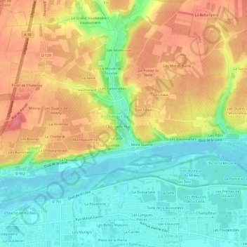
Name: Près d'Eglise topographic map, elevation, terrain.
Average elevation: 78 m
Minimum elevation: 44 m
Maximum elevation: 116 m
Other topographic maps
Click on a map to view its topography, its elevation and its terrain.
La Grande Rue
France > Centre-Val de Loire > Indre-et-Loire > Rochecorbon
La Grande Rue, Rochecorbon, Tours, Indre-et-Loire, Centre-Val de Loire, France métropolitaine, 37210, France
Average elevation: 77 m
Mont-Guerre
France > Centre-Val de Loire > Indre-et-Loire > Rochecorbon
Mont-Guerre, Rochecorbon, Arrondissement de Tours, Indre-et-Loire, Centre-Val de Loire, France métropolitaine, 37210, France
Average elevation: 73 m