
Brandweiher topographic map
Interactive map
Click on the map to display elevation.
About this map
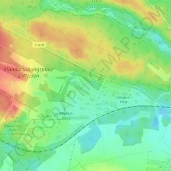
Name: Brandweiher topographic map, elevation, terrain.
Location: Brandweiher, Weiden in der Oberpfalz, Bayern, Deutschland (49.68775 12.08445 49.69153 12.09151)
Average elevation: 426 m
Minimum elevation: 400 m
Maximum elevation: 459 m
Other topographic maps
Click on a map to view its topography, its elevation and its terrain.
Weiden in der Oberpfalz
Deutschland > Bayern > Weiden in der Oberpfalz
Am 1. September 2007 übernahm Kurt Seggewiß (SPD) das Amt des Oberbürgermeisters von Hans Schröpf (CSU). Nach zwei Verurteilungen wegen Untreue und Steuerhinterziehung zum Vorteil der Stadtverwaltung trat Hans Schröpf aus gesundheitlichen Gründen von seinem Amt zurück, so dass es zu einer vorgezogenen…
Average elevation: 436 m
Maierhof
Deutschland > Bayern > Weiden in der Oberpfalz > Ullersricht > Maierhof
Average elevation: 420 m