
Thank you for supporting this site ❤️
Make a donation
Make a donation
Boussu topographic map
Click on the map to display elevation.
Thank you for supporting this site ❤️
Make a donation
Make a donation
Boussu
Boussu is sterk getekend door de industrie en verstedelijking. Ten noorden van Boussu stroomt de Hene. De hoogte aan de kerk bedraagt 36 meter.
Thank you for supporting this site ❤️
Make a donation
Make a donation
About this map
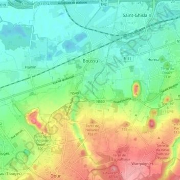
Name: Boussu topographic map, elevation, terrain.
Location: Boussu, Bergen, Henegouwen, Wallonië, België (50.39499 3.75866 50.45224 3.84355)
Average elevation: 53 m
Minimum elevation: 14 m
Maximum elevation: 119 m
Thank you for supporting this site ❤️
Make a donation
Make a donation
Other topographic maps
Click on a map to view its topography, its elevation and its terrain.
Thank you for supporting this site ❤️
Make a donation
Make a donation
Thank you for supporting this site ❤️
Make a donation
Make a donation
Sirault
België > Henegouwen > Bergen > Saint-Ghislain
De hoogte aan de kerk bedraagt 67 meter.
Average elevation: 74 m
Thank you for supporting this site ❤️
Make a donation
Make a donation
Thank you for supporting this site ❤️
Make a donation
Make a donation