
Δεσκάτη topographic map
Interactive map
Click on the map to display elevation.
About this map
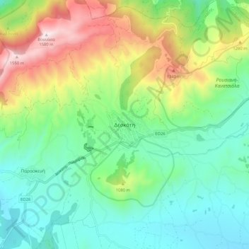
Name: Δεσκάτη topographic map, elevation, terrain.
Average elevation: 952 m
Minimum elevation: 656 m
Maximum elevation: 1,598 m
Other topographic maps
Click on a map to view its topography, its elevation and its terrain.
Γρεβενά
Griechenland > Epirus - Westmakedonien > Regionalbezirk Grevena
Γρεβενά, Δήμος Γρεβενών, Regionalbezirk Grevena, Region Westmakedonien, Epirus - Westmakedonien, 511 00, Griechenland
Average elevation: 583 m