
Insheim topographic map
Interactive map
Click on the map to display elevation.
About this map
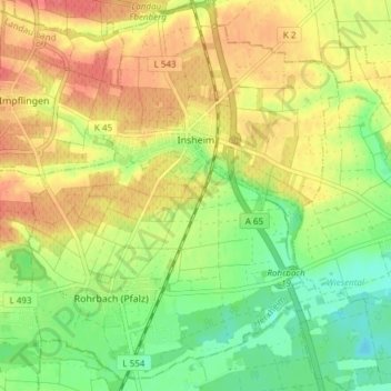
Name: Insheim topographic map, elevation, terrain.
Average elevation: 145 m
Minimum elevation: 115 m
Maximum elevation: 174 m
Other topographic maps
Click on a map to view its topography, its elevation and its terrain.
Böbingen
Deutschland > Rheinland-Pfalz > Landkreis Südliche Weinstraße
Böbingen, Edenkoben, Landkreis Südliche Weinstraße, Rheinland-Pfalz, Deutschland
Average elevation: 141 m
Billigheim
Deutschland > Rheinland-Pfalz > Landkreis Südliche Weinstraße
Billigheim, Billigheim-Ingenheim, Landau-Land, Landkreis Südliche Weinstraße, Rheinland-Pfalz, 76831, Deutschland
Average elevation: 158 m
Gommersheim
Deutschland > Rheinland-Pfalz > Landkreis Südliche Weinstraße
Gommersheim, Edenkoben, Landkreis Südliche Weinstraße, Rheinland-Pfalz, 67377, Deutschland
Average elevation: 135 m
Prestenberg
Deutschland > Rheinland-Pfalz > Landkreis Südliche Weinstraße > Eußerthal
Prestenberg, Eußerthal, Annweiler am Trifels, Landkreis Südliche Weinstraße, Rheinland-Pfalz, 76855, Deutschland
Average elevation: 325 m