
Ampfurth topographic map
Interactive map
Click on the map to display elevation.
About this map
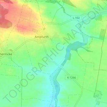
Name: Ampfurth topographic map, elevation, terrain.
Location: Ampfurth, Oschersleben, Börde, Sachsen-Anhalt, Deutschland (52.03568 11.29805 52.07644 11.34461)
Average elevation: 109 m
Minimum elevation: 81 m
Maximum elevation: 161 m
Other topographic maps
Click on a map to view its topography, its elevation and its terrain.
Oschersleben
Deutschland > Sachsen-Anhalt > Oschersleben
Oschersleben, Börde, Sachsen-Anhalt, 39387, Deutschland
Average elevation: 102 m
Hornhausen
Deutschland > Sachsen-Anhalt > Oschersleben
Hornhausen, Oschersleben, Börde, Sachsen-Anhalt, Deutschland
Average elevation: 105 m