
Byrnedale topographic map
Interactive map
Click on the map to display elevation.
About this map
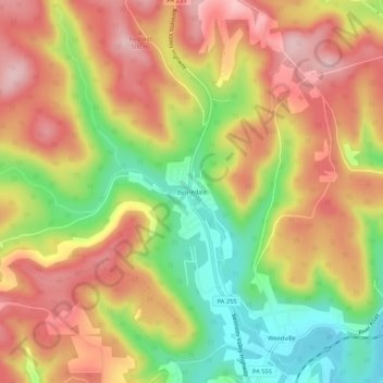
Name: Byrnedale topographic map, elevation, terrain.
Average elevation: 459 m
Minimum elevation: 344 m
Maximum elevation: 552 m
Other topographic maps
Click on a map to view its topography, its elevation and its terrain.
Force
United States > Pennsylvania > Elk County > Jay Township
Force, Jay Township, Elk County, Pennsylvania, 15841, United States
Average elevation: 444 m
Jay Township
United States > Pennsylvania > Elk County > Jay Township
Jay Township, Elk County, Pennsylvania, United States
Average elevation: 520 m
Weedville
United States > Pennsylvania > Elk County > Jay Township
Weedville, Jay Township, Elk County, Pennsylvania, 15827, United States
Average elevation: 432 m