
Thank you for supporting this site ❤️
Make a donation
Make a donation
Lavegadas topographic map
Click on the map to display elevation.
Thank you for supporting this site ❤️
Make a donation
Make a donation
About this map
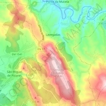
Name: Lavegadas topographic map, elevation, terrain.
Location: Lavegadas, Vila Nova de Poiares, Coimbra, Portugal (40.20258 -8.22119 40.25469 -8.16363)
Average elevation: 241 m
Minimum elevation: 71 m
Maximum elevation: 460 m
Thank you for supporting this site ❤️
Make a donation
Make a donation
Other topographic maps
Click on a map to view its topography, its elevation and its terrain.