
Thank you for supporting this site ❤️
Make a donation
Make a donation
Staffelberg topographic map
Click on the map to display elevation.
Thank you for supporting this site ❤️
Make a donation
Make a donation
About this map
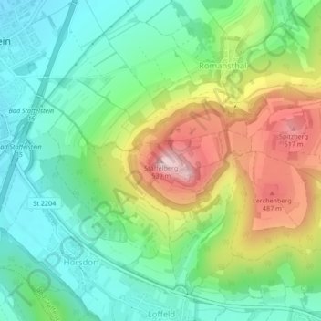
Name: Staffelberg topographic map, elevation, terrain.
Average elevation: 361 m
Minimum elevation: 266 m
Maximum elevation: 532 m
Thank you for supporting this site ❤️
Make a donation
Make a donation
Other topographic maps
Click on a map to view its topography, its elevation and its terrain.
https://www.regierung.oberfranken.bayern.de/nsg/5-35/5-35-02-Verordnung.pdf
Deutschland > Bayern > Landkreis Lichtenfels > Bad Staffelstein > Romansthal
Average elevation: 360 m
Trimeusel
Deutschland > Bayern > Landkreis Lichtenfels > Bad Staffelstein > Nedensdorf
Average elevation: 288 m