
Kerzuc topographic map
Interactive map
Click on the map to display elevation.
About this map
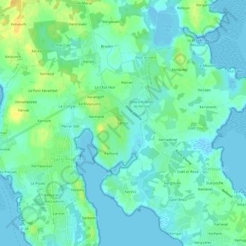
Name: Kerzuc topographic map, elevation, terrain.
Average elevation: 8 m
Minimum elevation: -2 m
Maximum elevation: 26 m
Other topographic maps
Click on a map to view its topography, its elevation and its terrain.
Kerroch
France > Bretagne > Morbihan > Saint-Philibert
Kerroch, Saint-Philibert, Lorient, Morbihan, Bretagne, France métropolitaine, 56470, France
Average elevation: 9 m
Kermouroux
France > Bretagne > Morbihan > Saint-Philibert
Kermouroux, Saint-Philibert, Lorient, Morbihan, Bretagne, France métropolitaine, 56470, France
Average elevation: 7 m
Larmor
France > Bretagne > Morbihan > Saint-Philibert
Larmor, Saint-Philibert, Lorient, Morbihan, Bretagne, France métropolitaine, 56470, France
Average elevation: 5 m
Pen er Stêr
France > Bretagne > Morbihan > Saint-Philibert > Pen er Stêr
Pen er Stêr, Saint-Philibert, Lorient, Morbihan, Bretagne, France métropolitaine, 56470, France
Average elevation: 8 m
Kerran
France > Bretagne > Morbihan > Saint-Philibert
Kerran, Saint-Philibert, Lorient, Morbihan, Bretagne, France métropolitaine, 56470, France
Average elevation: 9 m
Les Presses
France > Bretagne > Morbihan > Saint-Philibert
Les Presses, Saint-Philibert, Lorient, Morbihan, Bretagne, France métropolitaine, 56470, France
Average elevation: 7 m
Kerarno
France > Bretagne > Morbihan > Saint-Philibert
Kerarno, Saint-Philibert, Lorient, Morbihan, Bretagne, France métropolitaine, 56470, France
Average elevation: 5 m
Kernevest
France > Bretagne > Morbihan > Saint-Philibert
Kernevest, Saint-Philibert, Lorient, Morbihan, Bretagne, France métropolitaine, 56470, France
Average elevation: 3 m