
Thank you for supporting this site ❤️
Make a donation
Make a donation
Argela topographic map
Click on the map to display elevation.
Thank you for supporting this site ❤️
Make a donation
Make a donation
About this map
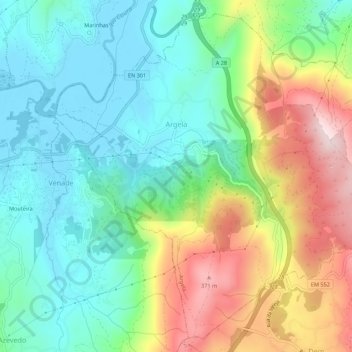
Name: Argela topographic map, elevation, terrain.
Location: Argela, Caminha, Viana do Castelo, Portugal (41.84232 -8.81067 41.87991 -8.75603)
Average elevation: 137 m
Minimum elevation: 0 m
Maximum elevation: 400 m
Thank you for supporting this site ❤️
Make a donation
Make a donation
Other topographic maps
Click on a map to view its topography, its elevation and its terrain.