
St. Johns County topographic map
Interactive map
Click on the map to display elevation.
About this map
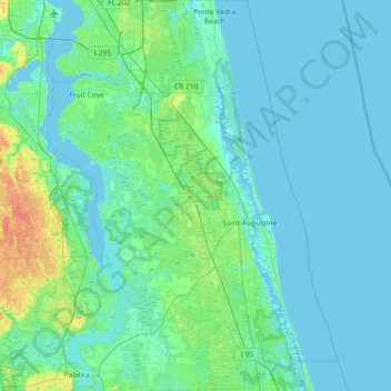
Name: St. Johns County topographic map, elevation, terrain.
Location: St. Johns County, Florida, United States of America (29.62243 -81.69047 30.25294 -81.15082)
Average elevation: 6 m
Minimum elevation: -5 m
Maximum elevation: 49 m
Other topographic maps
Click on a map to view its topography, its elevation and its terrain.
Palm Coast
United States of America > Florida > Palm Coast
Palm Coast, Flagler County, Florida, United States of America
Average elevation: 6 m