
Garaïbie topographic map
Interactive map
Click on the map to display elevation.
About this map
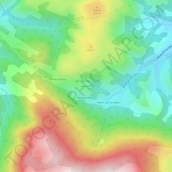
Name: Garaïbie topographic map, elevation, terrain.
Average elevation: 520 m
Minimum elevation: 211 m
Maximum elevation: 985 m
Other topographic maps
Click on a map to view its topography, its elevation and its terrain.
Lambarré
France > Nouvelle-Aquitaine > Pyrénées-Atlantiques > Ordiarp
Lambarré, Ordiarp, Oloron-Sainte-Marie, Pyrénées-Atlantiques, Nouvelle-Aquitaine, France métropolitaine, 64130, France
Average elevation: 219 m
Xübürü
France > Nouvelle-Aquitaine > Pyrénées-Atlantiques > Ordiarp
Xübürü, Ordiarp, Oloron-Sainte-Marie, Pyrénées-Atlantiques, Nouvelle-Aquitaine, France métropolitaine, 64130, France
Average elevation: 222 m