
Thank you for supporting this site ❤️
Make a donation
Make a donation
Lonigo topographic map
Click on the map to display elevation.
Thank you for supporting this site ❤️
Make a donation
Make a donation
About this map
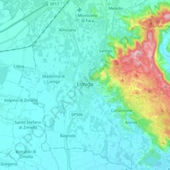
Name: Lonigo topographic map, elevation, terrain.
Location: Lonigo, Vicenza, Veneto, 36045, Italy (45.33634 11.33080 45.43828 11.45551)
Average elevation: 57 m
Minimum elevation: 16 m
Maximum elevation: 269 m
Thank you for supporting this site ❤️
Make a donation
Make a donation
Other topographic maps
Click on a map to view its topography, its elevation and its terrain.
Monte Cengio
Italy > Veneto > Vicenza > Cogollo del Cengio
Monte Cengio is a mountain in the Asiago plateau, within the Vicentine Alps, in Veneto, northeastern Italy. It has an elevation of 1,354 metres and is located on the southwestern edge of the plateau, in the territory of Cogollo del Cengio.
Average elevation: 935 m
Thank you for supporting this site ❤️
Make a donation
Make a donation
Thank you for supporting this site ❤️
Make a donation
Make a donation
Thank you for supporting this site ❤️
Make a donation
Make a donation
Thank you for supporting this site ❤️
Make a donation
Make a donation
Thank you for supporting this site ❤️
Make a donation
Make a donation