
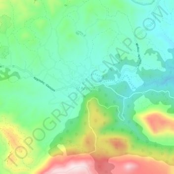
Αρχίπολη topographic map
Interactive map
Click on the map to display elevation.
About this map
Name: Αρχίπολη topographic map, elevation, terrain.
Average elevation: 256 m
Minimum elevation: 113 m
Maximum elevation: 554 m
Other topographic maps
Click on a map to view its topography, its elevation and its terrain.
Lindos
Griechenland > Ägäis > Regionalbezirk Rhodos
Lindos, Δήμος Ρόδου, Regionalbezirk Rhodos, Region Südliche Ägäis, Ägäis, 851 07, Griechenland
Average elevation: 47 m
Kolymbia
Griechenland > Ägäis > Regionalbezirk Rhodos
Kolymbia, Δήμος Ρόδου, Regionalbezirk Rhodos, Region Südliche Ägäis, Ägäis, 851 02, Griechenland
Average elevation: 31 m
Salakos
Griechenland > Ägäis > Regionalbezirk Rhodos > Salakos
Salakos, Δήμος Ρόδου, Regionalbezirk Rhodos, Region Südliche Ägäis, Ägäis, 85106, Griechenland
Average elevation: 287 m
Pefki
Griechenland > Ägäis > Regionalbezirk Rhodos
Pefki, Δήμος Ρόδου, Regionalbezirk Rhodos, Region Südliche Ägäis, Ägäis, 851 07, Griechenland
Average elevation: 42 m
Ialysos
Griechenland > Ägäis > Regionalbezirk Rhodos > Ialysos
Ialysos, Δήμος Ρόδου, Regionalbezirk Rhodos, Region Südliche Ägäis, Ägäis, 85101, Griechenland
Average elevation: 36 m