
Le Pont de Reynès topographic map
Interactive map
Click on the map to display elevation.
About this map
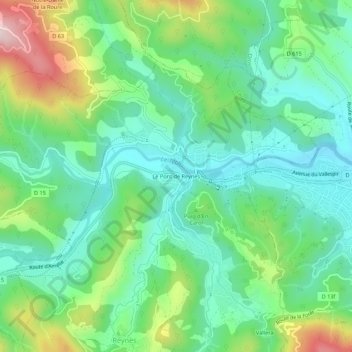
Name: Le Pont de Reynès topographic map, elevation, terrain.
Average elevation: 251 m
Minimum elevation: 129 m
Maximum elevation: 533 m
Other topographic maps
Click on a map to view its topography, its elevation and its terrain.
Canadells
France > Occitanie > Pyrénées-Orientales > Reynès
Canadells, Reynès, Céret, Pyrénées-Orientales, Occitanie, France métropolitaine, 66400, France
Average elevation: 409 m