Lake County topographic map
Interactive map
Click on the map to display elevation.
Lake County
Lake County has a mediterranean climate with hot summer daytime temperatures in its lower elevations. Nighttime temperatures remain cool year-round, somewhat moderating average temperatures and relieving the summer heat.
About this map
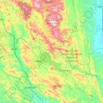
Name: Lake County topographic map, elevation, terrain.
Location: Lake County, California, United States of America (38.66765 -123.09417 39.58152 -122.33982)
Average elevation: 550 m
Minimum elevation: 23 m
Maximum elevation: 2,120 m
Other topographic maps
Click on a map to view its topography, its elevation and its terrain.
San Ramon
United States of America > California > San Ramon
The topography of San Ramon is varied, featuring a mix of the rolling hills of the Diablo Range and the flatter basin of the San Ramon Valley. The city is predominantly urban and residential with many new housing developments, however much of the land around the city's perimeter regions remains undeveloped,…
Average elevation: 210 m
Sunnyvale
United States of America > California > Sunnyvale
According to the United States Census Bureau, the city has a total area of 22.7 sq mi (58.8 km2), of which, 22.0 sq mi (56.9 km2) of it is land and 0.69 sq mi (1.8 km2) of it (3.09%) is water. Its elevation is 130 feet above sea level.
Average elevation: 24 m
Kings County
United States of America > California
Table Mountain is the highest point in Kings County at an elevation of 3,476 feet (1,059 m). It is located in the Diablo Range in southwestern Kings County on the boundary between Kings and Monterey counties.
Average elevation: 101 m
Beaumont
United States of America > California > Beaumont
Beaumont is a city in Riverside County, California, United States, located at a half-mile elevation in the pass area south of Southern California's highest peak, San Gorgonio Mountain, and north of San Jacinto Peak.
Average elevation: 725 m