
Thank you for supporting this site ❤️
Make a donation
Make a donation
Torres Vedras topographic map
Click on the map to display elevation.
Thank you for supporting this site ❤️
Make a donation
Make a donation
About this map
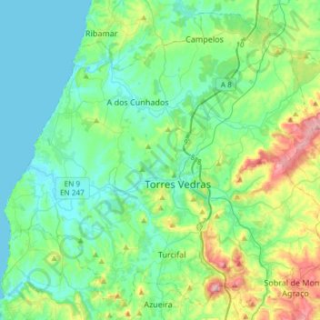
Name: Torres Vedras topographic map, elevation, terrain.
Location: Torres Vedras, Lisbon, Portugal (39.00407 -9.42210 39.21620 -9.12573)
Average elevation: 94 m
Minimum elevation: 0 m
Maximum elevation: 393 m
Thank you for supporting this site ❤️
Make a donation
Make a donation
Other topographic maps
Click on a map to view its topography, its elevation and its terrain.