
Thank you for supporting this site ❤️
Make a donation
Make a donation
Sucre topographic map
Click on the map to display elevation.
Thank you for supporting this site ❤️
Make a donation
Make a donation
About this map
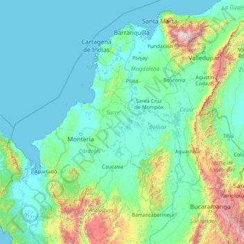
Name: Sucre topographic map, elevation, terrain.
Location: Sucre, Colombia (6.44000 -77.56000 11.56000 -72.44000)
Average elevation: 408 m
Minimum elevation: -4 m
Maximum elevation: 5,464 m
Thank you for supporting this site ❤️
Make a donation
Make a donation
Other topographic maps
Click on a map to view its topography, its elevation and its terrain.