
Thank you for supporting this site ❤️
Make a donation
Make a donation
Waller County topographic map
Click on the map to display elevation.
Thank you for supporting this site ❤️
Make a donation
Make a donation
About this map
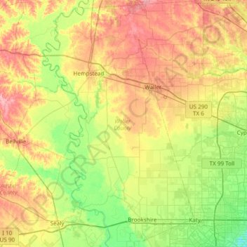
Name: Waller County topographic map, elevation, terrain.
Location: Waller County, Texas, United States (29.72794 -96.19228 30.24534 -95.80335)
Average elevation: 61 m
Minimum elevation: 21 m
Maximum elevation: 117 m
Thank you for supporting this site ❤️
Make a donation
Make a donation
Other topographic maps
Click on a map to view its topography, its elevation and its terrain.