
Thank you for supporting this site ❤️
Make a donation
Make a donation
Le Raval topographic map
Click on the map to display elevation.
Thank you for supporting this site ❤️
Make a donation
Make a donation
About this map
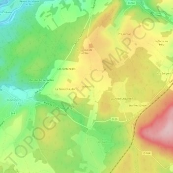
Name: Le Raval topographic map, elevation, terrain.
Average elevation: 373 m
Minimum elevation: 267 m
Maximum elevation: 492 m
Thank you for supporting this site ❤️
Make a donation
Make a donation
Other topographic maps
Click on a map to view its topography, its elevation and its terrain.
Bains-les-Bains
France > Grand Est > Vosges > La Vôge-les-Bains
Versant sud des monts Faucilles, le relief y est vallonné ; les altitudes les plus basses sont à l'ouest, où le canal de l'Est délimite les communes d'Hautmougey et de Fontenoy-le-Château.
Average elevation: 354 m
Bains-les-Bains
France > Grand Est > Vosges > La Vôge-les-Bains
Versant sud des monts Faucilles, le relief y est vallonné ; les altitudes les plus basses sont à l'ouest, où le canal de l'Est délimite les communes d'Hautmougey et de Fontenoy-le-Château.
Average elevation: 354 m