
Make a donation
Fond du Lac County topographic map
Click on the map to display elevation.
Make a donation
About this map
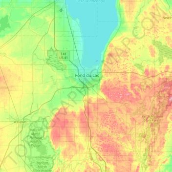
Name: Fond du Lac County topographic map, elevation, terrain.
Location: Fond du Lac County, Wisconsin, United States (43.54290 -88.88600 43.93876 -88.15974)
Average elevation: 284 m
Minimum elevation: 224 m
Maximum elevation: 393 m
Make a donation
Other topographic maps
Click on a map to view its topography, its elevation and its terrain.
Make a donation
Milwaukee River Floodplain Forest State Natural Area
United States > Wisconsin > Washington County
Average elevation: 291 m
Make a donation
Observatory Hill State Natural Area
United States > Wisconsin > Marquette County
Average elevation: 262 m
Make a donation
Make a donation
Make a donation
Parfrey's Glen State Natural Area
United States > Wisconsin > Sauk County > Town of Merrimac
Average elevation: 360 m
Make a donation
Blue Mound State Park
United States > Wisconsin > Iowa County > Town of Brigham
Average elevation: 416 m
Make a donation
Northern Wisconsin State Fairgrounds
United States > Wisconsin > Chippewa County > Chippewa Falls
Average elevation: 279 m
Make a donation
Make a donation
Wildcat Mountain State Park
United States > Wisconsin > Vernon County > Town of Whitestown
Average elevation: 310 m
Make a donation
Make a donation
Make a donation
Make a donation
Englewood
United States > Wisconsin > Columbia County > Town of Fountain Prairie
Average elevation: 276 m
Make a donation
Make a donation
Black River Falls
United States > Wisconsin > Jackson County > Black River Falls
Average elevation: 264 m
Perrot State Park
United States > Wisconsin > Trempealeau County > Town of Trempealeau
Average elevation: 223 m
Make a donation
Make a donation
Fox Lake Junction
United States > Wisconsin > Dodge County > Town of Fox Lake
Average elevation: 272 m
Make a donation
Make a donation
Isthmus Path Prairie Garden
United States > Wisconsin > Dane County > Madison
Average elevation: 262 m
Make a donation
Marinette County Beech Forest State Natural Area
United States > Wisconsin > Marinette County
Average elevation: 371 m
Make a donation
Wilderness Lake
United States > Wisconsin > Bayfield County > Town of Drummond
Average elevation: 391 m
Make a donation
McAllister
United States > Wisconsin > Marinette County
McAllister is located at the intersection of Wisconsin Highway 180 and County Highway JJ 11.5 miles (18.5 km) east-southeast of Wausaukee at an elevation of 692 feet (211 m). It is connected by road to Wausaukee to the west, Packard to the north, Wagner to the south, and Wallace, Michigan, to the east via a…
Average elevation: 210 m
Sheboygan Marsh 2 WP 319 Dam
United States > Wisconsin > Sheboygan County > Town of Russell
Average elevation: 284 m
Make a donation
Governor Dodge State Park
United States > Wisconsin > Iowa County > Town of Dodgeville
Average elevation: 336 m
Wildcat Mountain State Park
United States > Wisconsin > Vernon County > Town of Whitestown
Average elevation: 310 m
Make a donation
Graham Corners
United States > Wisconsin > Fond du Lac County > Town of Forest
Average elevation: 323 m
Yellowstone Lake State Park
United States > Wisconsin > Lafayette County > Blanchardville > Town of Fayette
Average elevation: 288 m
Make a donation