
Lac du Verney topographic map
Interactive map
Click on the map to display elevation.
About this map
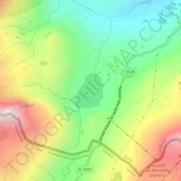
Name: Lac du Verney topographic map, elevation, terrain.
Location: Lac du Verney, sentiero T, La Thuile, Vallée d'Aoste, Italie (45.68558 6.87897 45.69092 6.88529)
Average elevation: 2,231 m
Minimum elevation: 1,883 m
Maximum elevation: 2,706 m
Other topographic maps
Click on a map to view its topography, its elevation and its terrain.
Mont Belvédère
Italie > Vallée d'Aoste > La Thuile
Mont Belvédère, La Thuile, Vallée d'Aoste, Italie
Average elevation: 2,395 m
Mont Valaisan
Italie > Vallée d'Aoste > La Thuile
Mont Valaisan, La Thuile, Vallée d'Aoste, Italie
Average elevation: 2,536 m
Entrèves
Italie > Vallée d'Aoste > La Thuile
Entrèves, La Thuile, Vallée d'Aoste, 11016, Italie
Average elevation: 1,828 m
Pian de la Lière
Italie > Vallée d'Aoste > La Thuile
Pian de la Lière, Glacier, La Thuile, Vallée d'Aoste, 11016, Italie
Average elevation: 2,279 m
Pont Serrand
Italie > Vallée d'Aoste > La Thuile
Pont Serrand, La Thuile, Vallée d'Aoste, 11016, Italie
Average elevation: 1,925 m
Villaret
Italie > Vallée d'Aoste > La Thuile
Villaret, La Thuile, Vallée d'Aoste, 11016, Italie
Average elevation: 1,897 m
Magnard
Italie > Vallée d'Aoste > La Thuile > Magnard
Magnard, La Thuile, Vallée d'Aoste, 11016, Italie
Average elevation: 2,068 m
Arolley
Italie > Vallée d'Aoste > La Thuile > Arolley
Arolley, La Thuile, Vallée d'Aoste, Italie
Average elevation: 2,206 m
Bella Valletta
Italie > Vallée d'Aoste > La Thuile
Bella Valletta, La Thuile, Vallée d'Aoste, Italie
Average elevation: 2,548 m
Pointe de la Louïe Blanche
Italie > Vallée d'Aoste > La Thuile
Pointe de la Louïe Blanche, La Thuile, Vallée d'Aoste, Italie
Average elevation: 2,580 m