
Thank you for supporting this site ❤️
Make a donation
Make a donation
Otricoli topographic map
Click on the map to display elevation.
Thank you for supporting this site ❤️
Make a donation
Make a donation
About this map
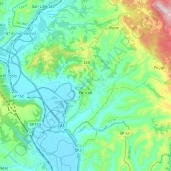
Name: Otricoli topographic map, elevation, terrain.
Location: Otricoli, Terni, Umbria, 05030, Italy (42.39443 12.44343 42.46099 12.59624)
Average elevation: 162 m
Minimum elevation: 37 m
Maximum elevation: 597 m
Thank you for supporting this site ❤️
Make a donation
Make a donation
Other topographic maps
Click on a map to view its topography, its elevation and its terrain.