
Thank you for supporting this site ❤️
Make a donation
Make a donation
Halen topographic map
Click on the map to display elevation.
Thank you for supporting this site ❤️
Make a donation
Make a donation
Halen
Halen ligt op de grens van Haspengouw en Hageland. De gemeente ligt aan de Velpe en de samenvloeiing van de Demer en de Gete. De Velpe mondt in Zelk in de Demer. Iets voor de monding van de Gete komt de Herk uit in de Gete. Ook de (gekanaliseerde) Melsterbeek komt op de grens met Donk ter hoogte van Halen in de Gete.
Thank you for supporting this site ❤️
Make a donation
Make a donation
About this map
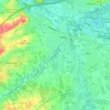
Name: Halen topographic map, elevation, terrain.
Location: Halen, Hasselt, Limburg, Vlaanderen, België (50.90898 5.04151 50.96773 5.13435)
Average elevation: 30 m
Minimum elevation: 13 m
Maximum elevation: 68 m
Thank you for supporting this site ❤️
Make a donation
Make a donation
Other topographic maps
Click on a map to view its topography, its elevation and its terrain.