
Thank you for supporting this site ❤️
Make a donation
Make a donation
Rossana topographic map
Click on the map to display elevation.
Thank you for supporting this site ❤️
Make a donation
Make a donation
About this map
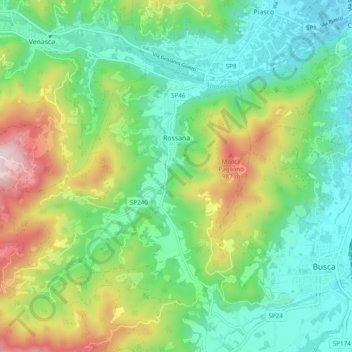
Name: Rossana topographic map, elevation, terrain.
Location: Rossana, Cuneo, Piedmont, Italy (44.51291 7.35766 44.55882 7.45422)
Average elevation: 662 m
Minimum elevation: 448 m
Maximum elevation: 1,132 m
Thank you for supporting this site ❤️
Make a donation
Make a donation
Other topographic maps
Click on a map to view its topography, its elevation and its terrain.
Thank you for supporting this site ❤️
Make a donation
Make a donation
Mont Vallonnet Nord / Cima las Blancias
Italy > Piedmont > Cuneo > Pietraporzio
Average elevation: 2,522 m