
Make a donation
Kamakura topographic map
Click on the map to display elevation.
Make a donation
Kamakura
The Kamakura shogunate era is called by historians the Kamakura period and, although its end is clearly set (Siege of Kamakura (1333)), its beginning is not. Different historians put Kamakura's beginning at a different point in time within a range that goes from the establishment of Yoritomo's first military government in Kamakura (1180) to his elevation to the rank of Sei-i Taishōgun (征夷大将軍) in 1192. It used to be thought that during this period, effective power had moved completely from the Emperor in Kyoto to Yoritomo in Kamakura, but the progress of research has revealed this was not the case. Even after the consolidation of the shogunate's power in the east, the Emperor continued to rule the country, particularly its west. However, it is undeniable that Kamakura had a certain autonomy and that it had surpassed the technical capital of Japan politically, culturally and economically. The shogunate even reserved for itself an area in Kyoto called Rokuhara (六波羅) where lived its representatives, who were there to protect its interests.
Make a donation
About this map
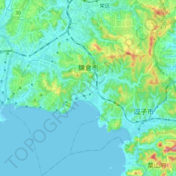
Name: Kamakura topographic map, elevation, terrain.
Location: Kamakura, Kanagawa Prefecture, Japan (35.26656 139.48855 35.36831 139.59317)
Average elevation: 33 m
Minimum elevation: -1 m
Maximum elevation: 201 m
Make a donation
Other topographic maps
Click on a map to view its topography, its elevation and its terrain.
Mt. Fuji
Japan > Sunto County > Oyama
Mount Fuji (富士山, Fujisan, Japanese: [ɸɯꜜ(d)ʑisaɴ] ) is an active stratovolcano located on the Japanese island of Honshu, with a summit elevation of 3,776.24 m (12,389 ft 3 in). It is the tallest mountain in Japan, the second-highest volcano located on an island in Asia (after Mount Kerinci on the…
Average elevation: 3,261 m
Make a donation