
Thank you for supporting this site ❤️
Make a donation
Make a donation
Fernandes topographic map
Click on the map to display elevation.
Thank you for supporting this site ❤️
Make a donation
Make a donation
About this map
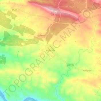
Name: Fernandes topographic map, elevation, terrain.
Location: Fernandes, Mértola, Beja, 7750-313, Portugal (37.59959 -7.63967 37.63959 -7.59967)
Average elevation: 117 m
Minimum elevation: -4 m
Maximum elevation: 217 m
Thank you for supporting this site ❤️
Make a donation
Make a donation
Other topographic maps
Click on a map to view its topography, its elevation and its terrain.
São Miguel do Pinheiro, São Pedro de Solis e São Sebastião dos Carros
Average elevation: 206 m
Thank you for supporting this site ❤️
Make a donation
Make a donation