
Cairo Montenotte topographic map
Interactive map
Click on the map to display elevation.
About this map
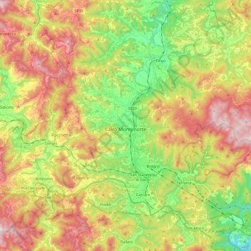
Name: Cairo Montenotte topographic map, elevation, terrain.
Location: Cairo Montenotte, Savone, Ligurie, Italie (44.34679 8.20775 44.45589 8.43183)
Average elevation: 490 m
Minimum elevation: 183 m
Maximum elevation: 852 m
Other topographic maps
Click on a map to view its topography, its elevation and its terrain.
Le Ville
Italie > Ligurie > Savone > Cairo Montenotte
Le Ville, Cairo Montenotte, Savone, Ligurie, 17014, Italie
Average elevation: 408 m
Celle Ligure
Celle Ligure, Savone, Ligurie, 17015, Italie
Average elevation: 120 m
Calice Ligure
Calice Ligure, Savone, Ligurie, Italie
Average elevation: 493 m
Finale Ligure
Finale Ligure, Savone, Ligurie, 17024, Italie
Average elevation: 163 m
Pietra Ligure
Pietra Ligure, Savone, Ligurie, 17027, Italie
Average elevation: 109 m