
Gersau topographic map
Interactive map
Click on the map to display elevation.
About this map
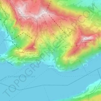
Name: Gersau topographic map, elevation, terrain.
Location: Gersau, Schwyz, 6442, Suisse (46.97643 8.46523 47.02795 8.56153)
Average elevation: 819 m
Minimum elevation: 423 m
Maximum elevation: 1,671 m
Other topographic maps
Click on a map to view its topography, its elevation and its terrain.
Lac des Quatre Cantons
Lac des Quatre Cantons, Gersau, Schwyz, Suisse
Average elevation: 886 m