
Groß Woltersdorf topographic map
Interactive map
Click on the map to display elevation.
About this map
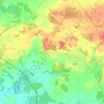
Name: Groß Woltersdorf topographic map, elevation, terrain.
Average elevation: 91 m
Minimum elevation: 60 m
Maximum elevation: 127 m
Other topographic maps
Click on a map to view its topography, its elevation and its terrain.
Naturbad Groß Wolterdorf
Deutschland > Brandenburg > Groß Pankow (Prignitz) > Groß Woltersdorf
Naturbad Groß Wolterdorf, Am Märchenwald, Groß Woltersdorf, Groß Pankow (Prignitz), Prignitz, Brandenburg, 16928, Deutschland
Average elevation: 95 m
Retzin
Deutschland > Brandenburg > Groß Pankow (Prignitz)
Retzin, Groß Pankow (Prignitz), Prignitz, Brandenburg, Deutschland
Average elevation: 53 m