Geolocate

Bioglio topographic map

Interactive map

Click on the map to display elevation.

About this map

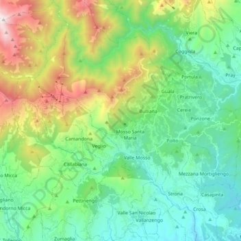
Name: Bioglio topographic map, elevation, terrain.

Location: Bioglio, Biella, Piedmont, Italy (45.59262 8.00359 45.71379 8.15350)

Average elevation: 788 m

Minimum elevation: 300 m

Maximum elevation: 2,027 m

Other topographic maps

Click on a map to view its topography, its elevation and its terrain.

Rongio Superiore

Italy > Piedmont > Biella > Masserano

Average elevation: 318 m

Mucengo

Italy > Piedmont > Biella > Pray

Average elevation: 528 m

Polto

Italy > Piedmont > Biella

Average elevation: 557 m

Bose

Italy > Piedmont > Biella > Valle Mosso

Average elevation: 587 m

Asmara

Italy > Piedmont > Biella > Campiglia Cervo

Average elevation: 1,112 m

Pianezze

Italy > Piedmont > Biella > Camandona

Average elevation: 683 m

Trappa - Bagneri

Italy > Piedmont > Biella > Sordevolo

Average elevation: 1,045 m

Fantone

Italy > Piedmont > Biella > Mosso Santa Maria

Average elevation: 765 m

Valmosca

Italy > Piedmont > Biella > Campiglia Cervo

Average elevation: 1,223 m

Frieri

Italy > Piedmont > Biella > Bulliana

Average elevation: 762 m

Dagostino

Italy > Piedmont > Biella > Camandona

Average elevation: 704 m

Triverio

Italy > Piedmont > Biella > Bioglio

Average elevation: 550 m

Bulliana

Italy > Piedmont > Biella

Average elevation: 770 m

Crocemosso

Italy > Piedmont > Biella > Aviè

Average elevation: 595 m

Rialmosso

Italy > Piedmont > Biella > Campiglia Cervo

Average elevation: 1,051 m

Nicoletto

Italy > Piedmont > Biella > Valle Mosso

Average elevation: 593 m

Oasi Zegna

Italy > Piedmont > Biella > Guala

Average elevation: 1,028 m

Parcarissa

Italy > Piedmont > Biella > Netro

Average elevation: 581 m