
Zottewitz topographic map
Interactive map
Click on the map to display elevation.
About this map
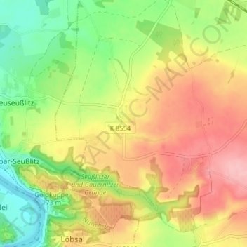
Name: Zottewitz topographic map, elevation, terrain.
Location: Zottewitz, Priestewitz, Meißen, Sachsen, Deutschland (51.22627 13.42717 51.26627 13.46717)
Average elevation: 154 m
Minimum elevation: 92 m
Maximum elevation: 216 m
Other topographic maps
Click on a map to view its topography, its elevation and its terrain.
Stauda
Deutschland > Sachsen > Meißen > Priestewitz
Stauda, Priestewitz, Meißen, Sachsen, 01558, Deutschland
Average elevation: 152 m
Kmehlen
Deutschland > Sachsen > Meißen > Priestewitz > Kmehlen
Kmehlen, Priestewitz, Meißen, Sachsen, Deutschland
Average elevation: 171 m