
Leek topographic map
Interactive map
Click on the map to display elevation.
About this map
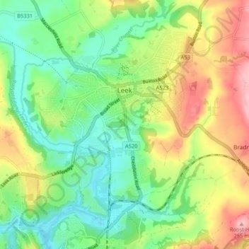
Name: Leek topographic map, elevation, terrain.
Average elevation: 193 m
Minimum elevation: 135 m
Maximum elevation: 285 m
Other topographic maps
Click on a map to view its topography, its elevation and its terrain.
The Cloud
Vereinigtes Königreich > England > Staffordshire > Staffordshire Moorlands
The Cloud, Cloudside, Rushton, Staffordshire Moorlands, Staffordshire, England, CW12 3QG, Vereinigtes Königreich
Average elevation: 194 m
Farley
Vereinigtes Königreich > England > Staffordshire > Staffordshire Moorlands
Farley, Staffordshire Moorlands, Staffordshire, England, Vereinigtes Königreich
Average elevation: 221 m
Quarnford
Vereinigtes Königreich > England > Staffordshire > Staffordshire Moorlands > Flash
Quarnford, Flash, Staffordshire Moorlands, Staffordshire, England, Vereinigtes Königreich
Average elevation: 408 m