
Make a donation
Lafayette County topographic map
Click on the map to display elevation.
Make a donation
About this map
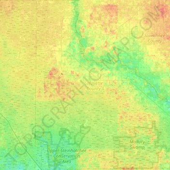
Name: Lafayette County topographic map, elevation, terrain.
Location: Lafayette County, Florida, United States (29.82068 -83.37089 30.26067 -82.87528)
Average elevation: 22 m
Minimum elevation: 5 m
Maximum elevation: 47 m
Make a donation
Other topographic maps
Click on a map to view its topography, its elevation and its terrain.
Jacksonville
United States > Florida > Duval County > Jacksonville
Just south of Jacksonville and north of Saint Augustine is the boundary of where the Floridian Peninsula ends and Continental North America begins; Jacksonville is north of that line. While still in the North American Coastal plain, the topography begins to take on slight Piedmont characteristics. Like the…
Average elevation: 9 m
Make a donation
Deerfield Beach Century Village
United States > Florida > Broward County > Deerfield Beach
Average elevation: 8 m
Make a donation
Make a donation
Make a donation
Make a donation
Make a donation
Make a donation
Make a donation
Make a donation
Make a donation
Make a donation
Make a donation
Ave Maria
United States > Florida > Collier County
Ave Maria is 36 miles northeast of downtown Naples, Florida, and part of Collier County. The town's elevation is 18 feet. According to the United States Census Bureau, the city has a total area of 10.424sq mi (27.01km2).
Average elevation: 8 m
Make a donation
Make a donation
Make a donation
Make a donation
Make a donation
Make a donation
Make a donation
Deering Innovation Park
United States > Florida > Volusia County > New Smyrna Beach
Average elevation: 8 m
Highland Woods Golf & Country Club
United States > Florida > Lee County > Bonita Springs
Average elevation: 5 m
South Patrick Shores
United States > Florida > Brevard County > Satellite Beach
Average elevation: 2 m
Make a donation
Make a donation
Make a donation
Make a donation
Miami
United States > Florida > Miami-Dade County
Miami and its suburbs are located on a broad plain between the Everglades to the west and Biscayne Bay to the east, which extends from Lake Okeechobee southward to Florida Bay. The elevation of the area averages at around 6 ft (1.8 m) above sea level in most neighborhoods, especially near the coast. The…
Average elevation: 4 m
West Samoset
United States > Florida > Manatee County > South Bradenton > West Samoset
Average elevation: 11 m
Make a donation
Make a donation