Puno topographic map
Interactive map
Click on the map to display elevation.
About this map
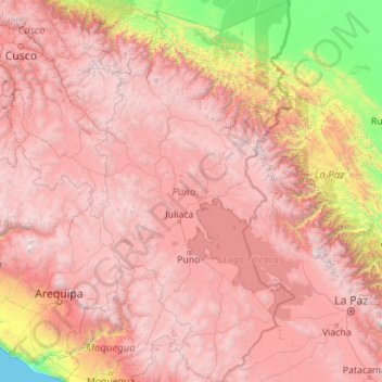
Name: Puno topographic map, elevation, terrain.
Location: Puno, Peru (-17.29525 -71.11809 -13.00413 -68.79549)
Average elevation: 3,150 m
Minimum elevation: 0 m
Maximum elevation: 6,251 m
Other topographic maps
Click on a map to view its topography, its elevation and its terrain.
Ica
Ica has significant wine and pisco industries, annual fiestas, a museum and historic colonial churches. The climate is generally sunny and dry due to its elevation above coastal fog and mist. As of 2020, the Peruvian desert, around the Huacachina Oasis, has gotten significantly popular among tourists for…
Average elevation: 1,624 m
Piura
Topography is smooth in the coast and rough in the Sierra. There are many arid plains in the southern region. The Sechura Desert, located south of the Piura River, is Peru's largest desert and one of the world's few examples of a tropical desert; it borders a tropical terrain to the north. The Bayóvar…
Average elevation: 675 m
Arequipa
This department has a rough topography, which is characterised by heavy layers of volcanic lava covering large areas of its inter-Andean sector. It has deep canyons such as the ones formed by the Ocoña and Majes rivers. Plateaus range in height from medium, such as La Joya, and high-altitude ones such the…
Average elevation: 2,599 m
Tingo Maria National Park
Peru > Huánuco > Mariano Dámaso Beraún
Topography in the park is steep and mountainous, because the Bella Durmiente massif occupies almost of its entire extension. Elevations in the park are in the range of 650–1808 m; rocky walls of 300–500 m in height are common. Soils are calcareous, rocky and thin, and landslides due to natural causes or…
Average elevation: 1,136 m
La Rinconada
Peru > Puno > La Rinconada
High in the Andes, La Rinconada has an alpine tundra climate (ET, according to the Köppen climate classification), with no month having mean temperatures even close to the 10 °C (50 °F) threshold that would permit tree growth and a subtropical highland classification for the city. Far above the tree line,…
Average elevation: 4,646 m
Cajamarca
Cajamarca has a subtropical highland climate (Cwb, in the Köppen climate classification) which is characteristic of high elevations at tropical latitudes. This city presents a semi-dry, temperate, semi-cold climate with presence of rainfall mostly on spring and summer (from October to March) with little or no…
Average elevation: 1,456 m