
Make a donation
Santa Catarina topographic map
Click on the map to display elevation.
Make a donation
Santa Catarina
The highest point of the state is the Morro da Boa Vista, at an altitude of 1,827 m, and the second-highest point is the Morro da Igreja, in the town of Urubici, at an altitude of 1,822 m.
Make a donation
About this map
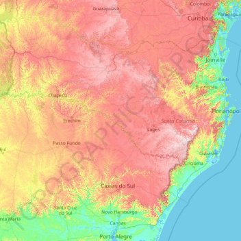
Name: Santa Catarina topographic map, elevation, terrain.
Location: Santa Catarina, South Region, Brazil (-29.44091 -53.83735 -25.95572 -48.10211)
Average elevation: 530 m
Minimum elevation: -3 m
Maximum elevation: 1,778 m
Make a donation
Other topographic maps
Click on a map to view its topography, its elevation and its terrain.
Brasília
Brazil > Federal District > Região Integrada de Desenvolvimento do Distrito Federal e Entorno
The city sits at an elevation of 1,000 metres (3,300 ft) and more, high on the Brazilian Highlands in the country's center-western region. Paranoá Lake, a large artificial lake, was built to increase the amount of water available and to maintain the region's humidity. It has a marina, and hosts wakeboarders…
Average elevation: 1,084 m
Região Metropolitana do Recife
Brazil > Pernambuco > Região Metropolitana do Recife > Cabo de Santo Agostinho
Average elevation: 119 m
Make a donation