
Sierße topographic map
Interactive map
Click on the map to display elevation.
About this map
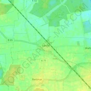
Name: Sierße topographic map, elevation, terrain.
Average elevation: 79 m
Minimum elevation: 70 m
Maximum elevation: 87 m
Other topographic maps
Click on a map to view its topography, its elevation and its terrain.
Bodenstedt
Deutschland > Niedersachsen > Landkreis Peine > Vechelde
Bodenstedt, Vechelde, Landkreis Peine, Niedersachsen, 38268, Deutschland
Average elevation: 84 m
Groß Gleidingen
Deutschland > Niedersachsen > Landkreis Peine > Vechelde
Groß Gleidingen, Vechelde, Landkreis Peine, Niedersachsen, 38159, Deutschland
Average elevation: 83 m
Wahle
Deutschland > Niedersachsen > Landkreis Peine > Vechelde > Wahle
Wahle, Vechelde, Landkreis Peine, Niedersachsen, 38159, Deutschland
Average elevation: 76 m