
Thank you for supporting this site ❤️
Make a donation
Make a donation
Central Denmark Region topographic map
Click on the map to display elevation.
Thank you for supporting this site ❤️
Make a donation
Make a donation
About this map
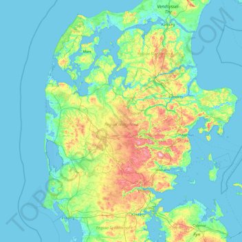
Name: Central Denmark Region topographic map, elevation, terrain.
Location: Central Denmark Region, Denmark (55.66887 8.09820 56.84659 11.66296)
Average elevation: 19 m
Minimum elevation: -5 m
Maximum elevation: 163 m
Thank you for supporting this site ❤️
Make a donation
Make a donation
Other topographic maps
Click on a map to view its topography, its elevation and its terrain.