
Make a donation
Madeira topographic map
Click on the map to display elevation.
Make a donation
Madeira
The archipelago includes the islands of Madeira, Porto Santo, and the Desertas, administered together with the separate archipelago of the Savage Islands. Roughly half of the region's population lives in Funchal. The region has political and administrative autonomy through the Administrative Political Statute of the Autonomous Region of Madeira provided for in the Portuguese Constitution. The autonomous region is an integral part of the European Union as an outermost region. Madeira generally has a very mild and moderate subtropical climate with mediterranean summer droughts and winter rain. Many microclimates are found at different elevations.
Make a donation
About this map
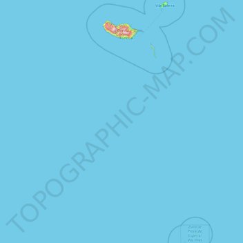
Name: Madeira topographic map, elevation, terrain.
Location: Madeira, Portugal (30.02878 -17.26593 33.12816 -15.85367)
Average elevation: 5 m
Minimum elevation: 0 m
Maximum elevation: 1,748 m
Make a donation
Other topographic maps
Click on a map to view its topography, its elevation and its terrain.
Make a donation
Make a donation
Braga
The topography in the municipality is characterized by irregular valleys, interspersed by mountainous spaces, fed by rivers running in parallel with the principal rivers. In the north it is limited by the Cávado River, in the south by terrain of the Serra dos Picos to a height of 566 metres (1,857 ft) and…
Average elevation: 204 m
Make a donation
São Brás de Alportel
Portugal > Faro > São Brás de Alportel > São Brás de Alportel
Average elevation: 254 m
Make a donation
Make a donation
Make a donation
Mount Pico
Mount Pico (Portuguese: Montanha do Pico) is a currently dormant stratovolcano located on Pico Island, in the mid-Atlantic archipelago of the Azores. It is the highest mountain in Portugal, at 2,351 metres (7,713 ft) above sea level, and is one of the highest Atlantic mountains; it is more than twice the…
Average elevation: 1,694 m
Make a donation
Make a donation
Sintra
Portugal > Lisbon > Sintra (Santa Maria e São Miguel, São Martinho e São Pedro de Penaferrim)
The São João platform, along the northern flank of the Sintra Mountains, has altitudes between 100 metres (110 yd) and 150 metres (160 yd), while the southern part of the mountains, the Cascais platform, is lower: sloping from 150 metres (160 yd) to the sea, terminating along the coast, around 30 metres (33…
Average elevation: 189 m
Make a donation
Ruivo
As the highest point in the archipelago, Pico Ruivo is primarily surrounded by high-altitude heath. The area is also marked by monumental rock formations, which often rise above the clouds, dominating the landscape. The region is home to several bird species, including the Madeira firecrest, the chaffinch, and…
Average elevation: 1,400 m
Make a donation
Relva da Asseiceira
Portugal > Portalegre > Marvão > Santo António das Areias
Average elevation: 482 m
Make a donation
Make a donation
Make a donation
Make a donation
Beloura
Portugal > Lisbon > Sintra (Santa Maria e São Miguel, São Martinho e São Pedro de Penaferrim)
Average elevation: 182 m
Make a donation
Algarve
The Algarve is located in the southernmost area of continental Portugal and the southwesternmost area of the Iberian Peninsula and mainland Europe, covering an area of 4,997 km2 (1,929 sq mi). It borders to the north with the Alentejo region (Alentejo Litoral and Baixo Alentejo), to the south and west with the…
Average elevation: 72 m
Make a donation
Make a donation
Monte Gordo
Portugal > Castelo Branco > Castelo Branco > Santo André das Tojeiras
Average elevation: 285 m
Make a donation
Make a donation
Make a donation
Make a donation
Make a donation
Mount Pico
Mount Pico (Portuguese: Montanha do Pico) is a currently dormant stratovolcano located on Pico Island, in the mid-Atlantic archipelago of the Azores. It is the highest mountain in Portugal, at 2,351 metres (7,713 ft) above sea level, and is one of the highest Atlantic mountains; it is more than twice the…
Average elevation: 1,694 m
Make a donation
Make a donation
Cidadelha de Jales
Portugal > Vila Real > Vila Pouca de Aguiar > Alfarela de Jales
Average elevation: 783 m
Make a donation