
Thank you for supporting this site ❤️
Make a donation
Make a donation
Kinsale topographic map
Click on the map to display elevation.
Thank you for supporting this site ❤️
Make a donation
Make a donation
About this map
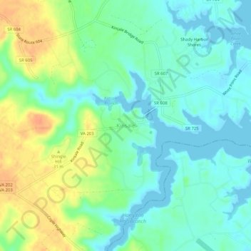
Name: Kinsale topographic map, elevation, terrain.
Location: Kinsale, Westmoreland County, Virginia, 22488, United States (38.00957 -76.60079 38.04957 -76.56079)
Average elevation: 14 m
Minimum elevation: -1 m
Maximum elevation: 40 m
Thank you for supporting this site ❤️
Make a donation
Make a donation
Other topographic maps
Click on a map to view its topography, its elevation and its terrain.