Geolocate

Backbone State Park topographic map

Interactive map

Click on the map to display elevation.

About this map

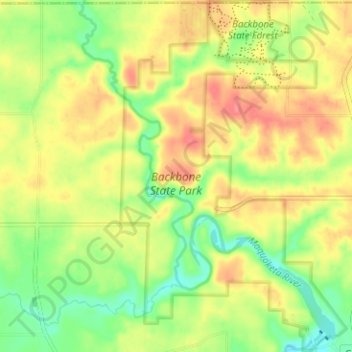
Name: Backbone State Park topographic map, elevation, terrain.

Location: Backbone State Park, Delaware County, Iowa, United States (42.59806 -91.57272 42.64433 -91.53209)

Average elevation: 333 m

Minimum elevation: 299 m

Maximum elevation: 366 m

Other topographic maps

Click on a map to view its topography, its elevation and its terrain.

Ryan

United States > Iowa > Delaware County

Ryan, Delaware County, Iowa, United States

Average elevation: 310 m

Delaware

United States > Iowa > Delaware County

Delaware, Delaware County, Iowa, 52036, United States

Average elevation: 322 m

Greeley

United States > Iowa > Delaware County

Greeley, Delaware County, Iowa, United States

Average elevation: 347 m

Colesburg

United States > Iowa > Delaware County

Colesburg, Delaware County, Iowa, United States

Average elevation: 345 m

Delhi

United States > Iowa > Delaware County

Delhi, Delaware County, Iowa, United States

Average elevation: 320 m

York

United States > Iowa > Delaware County

York, Delaware County, Iowa, United States

Average elevation: 340 m

Dundee

United States > Iowa > Delaware County

Dundee, Delaware County, Iowa, United States

Average elevation: 311 m

Earlville

United States > Iowa > Delaware County

Earlville, Delaware County, Iowa, United States

Average elevation: 310 m

Hopkinton

United States > Iowa > Delaware County

Hopkinton, Delaware County, Iowa, United States

Average elevation: 269 m

Masonville

United States > Iowa > Delaware County

Masonville, Delaware County, Iowa, United States

Average elevation: 309 m

Manchester

United States > Iowa > Delaware County

Manchester, Delaware County, Iowa, 52057, United States

Average elevation: 296 m