
Thank you for supporting this site ❤️
Make a donation
Make a donation
Caltojar topographic map
Click on the map to display elevation.
Thank you for supporting this site ❤️
Make a donation
Make a donation
About this map
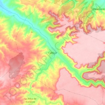
Name: Caltojar topographic map, elevation, terrain.
Location: Caltojar, Castilla y León, España (41.34694 -2.81973 41.45870 -2.67622)
Average elevation: 1,051 m
Minimum elevation: 921 m
Maximum elevation: 1,132 m
Thank you for supporting this site ❤️
Make a donation
Make a donation
Other topographic maps
Click on a map to view its topography, its elevation and its terrain.