
Make a donation
Rupprechtstegen topographic map
Click on the map to display elevation.
Make a donation
About this map
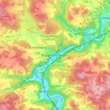
Name: Rupprechtstegen topographic map, elevation, terrain.
Average elevation: 460 m
Minimum elevation: 361 m
Maximum elevation: 547 m
Make a donation
Other topographic maps
Click on a map to view its topography, its elevation and its terrain.
Schnaittach
Deutschland > Bayern > Landkreis Nürnberger Land
Der Kernort Schnaittach liegt im Schnaittachtal am Fluss gleichen Namens, einem Nebenfluss der Pegnitz, westlich des Rothenbergs am Rande der Frankenalb. Der Untergrund (Höhen 330–400 m ü. NHN) besteht entweder aus Sandstein/Sand oder Lehm bzw. Hanggeröll der Fränkischen Alb. In Lagen über 400 Meter ist…
Average elevation: 451 m
Lauf an der Pegnitz
Deutschland > Bayern > Landkreis Nürnberger Land
Am letzten Juniwochenende findet rund um den Marktplatz das Laufer Altstadtfest mit einem umfangreichen musikalischen und kulinarischen Angebot statt, eine Woche später folgt mit dem Kunigundenfest eine für die Region besondere Kirchweih. Höhepunkte sind der Festumzug und eine Aufführung von Schülern der…
Average elevation: 366 m
Make a donation
Happurg
Deutschland > Bayern > Landkreis Nürnberger Land
Die Gemeinde hat 14 Gemeindeteile (in Klammern sind der Siedlungstyp, die Einwohnerzahlen Stand 30. September 2010 und die geografische Höhe angegeben).
Average elevation: 481 m
Rückersdorfer Forst
Deutschland > Bayern > Landkreis Nürnberger Land
Der Staatsforst ist ein nördlich von Rückersdorf gelegener Teil des Sebalder Reichswaldes. Im Norden grenzt der Günthersbühler Forst, im Osten die Laufer Gemeindeteile Rudolfshof und Kotzenhof der Stadt Lauf an der Pegnitz an, im Süden die Rückersdorfer Gemeindeteile Ludwigshöhe und Strengenberg und im…
Average elevation: 357 m
Burgthann
Deutschland > Bayern > Landkreis Nürnberger Land
Die höchste Schicht stellt der Dogger im Gemeindegebiet dar. Ein Höhenzug verläuft von Westhaid in Richtung Gespannberg. Östlich von Ezelsdorf, Osterhof führt ein bogenförmiger Dogger-Ausläufer zum Gespannberg. Der Hochpunkt dieser hügeligen Landschaft bildet der östlich des Gemeindegebiets…
Average elevation: 431 m
Make a donation
Neunkirchen a. Sand
Deutschland > Bayern > Landkreis Nürnberger Land
Das Wahrzeichen von Neunkirchen am Sand ist die katholische Pfarrkirche Maria Himmelfahrt. Auf einer Anhöhe im Ortskern prägt sie seit Jahrhunderten das Ortsbild. Bei der von dem ehemals stark befestigten Friedhof umgebenen Kirche handelt es sich um eine Kirchenburg. Die Umwallung umschloss außer der Kirche…
Average elevation: 355 m
Feucht
Deutschland > Bayern > Landkreis Nürnberger Land
Mit dem Beginn des Luftkrieges während des Zweiten Weltkrieges wurden in Feucht als Teil der Flugabwehr für Nürnberg mehrere Flak-Stellungen eingerichtet: an der Kreuzung Schwabacher Straße/B8, an der Altdorfer Straße auf Höhe des heutigen Freibads und am Fischbacher Weg. Flakscheinwerfer standen im…
Average elevation: 372 m
Make a donation
Offenhausen
Deutschland > Bayern > Landkreis Nürnberger Land
Aufgrund der geologischen Verhältnisse weist Offenhausen eine stark bewegte Topographie auf. Eine Vielzahl an Bergkuppen aus dem Jura prägt den abwechslungsreich geformten Landschaftsraum. Der 602 m ü. NHN hohe Lindenbühl ist die topographisch höchste Erhebung des Gemeindegebiets. Südlich von Offenhausen…
Average elevation: 503 m
Schwarzenbruck
Deutschland > Bayern > Landkreis Nürnberger Land
Die meisten Gemeindeteile der Gemeinde Schwarzenbruck sind von Wald umgeben. Im Norden erstreckt sich der Lorenzer Reichswald, im Süden der Südliche Reichswald. Gsteinach, Schwarzenbruck und Ochenbruck liegen im Tal der Schwarzach, Rummelsberg und Altenthann auf einem Höhenrücken nördlich der Schwarzach.…
Average elevation: 385 m
Make a donation
Hartenstein
Deutschland > Bayern > Landkreis Nürnberger Land
Gegenüber der Burg Hartenstein hat man vom Hirtenberg, der höchsten Erhebung von Hartenstein mit 563 m, bei schönem Wetter einen weiten Ausblick über die Frankenalb zur Burg Hohenstein, zur Burg Veldenstein bei Neuhaus, nach Auerbach und ins Fichtelgebirge. Zu den Sehenswürdigkeiten zählen der Löwenfels…
Average elevation: 460 m
Make a donation
Pommelsbrunn
Deutschland > Bayern > Landkreis Nürnberger Land
Das Gemeindegebiet weist eine stark bewegte Topografie auf und liegt auf einer Höhe von 400–650 m ü. NHN. Die Juralandschaft von Pommelsbrunn befindet sich in der naturräumlichen Haupteinheit Fränkische Alb und der Naturraum-Einheit Nördliche Frankenalb.
Average elevation: 466 m
Make a donation
Alfeld
Deutschland > Bayern > Landkreis Nürnberger Land
Die Gemeinde liegt etwa 35 Kilometer östlich von Nürnberg. Nächste Städte sind Hersbruck und Altdorf, beide circa 13 Kilometer entfernt. Die Topographie von Alfeld weist große Höhenunterschiede auf; der bewegte Landschaftsraum wird als Kuppenalb bezeichnet. Die Gemeinde befindet sich in der…
Average elevation: 533 m
Rückersdorf
Deutschland > Bayern > Landkreis Nürnberger Land
Es gibt auf dem Gemeindegebiet die Gemarkungen Rückersdorf und Rückersdorfer Forst (Gemarkungsteil 0). Die Grmarkung Rückersdorf hat eine Fläche von 3,520 km² und ist in 3071 Flurstücke aufgeteilt, die eine durchschnittliche Flurstücksfläche von 1146,27 m² haben. In ihr liegen neben dem namensgebenden…
Average elevation: 337 m
Make a donation
Make a donation
Leinburg
Deutschland > Bayern > Landkreis Nürnberger Land
Die Gemeinde liegt zwischen den Städten Lauf, Altdorf und Hersbruck. Die Autobahnen A 6 und A 9 umschließen Leinburg im Süden und Nordwesten und bieten über die Anschlussstellen Altdorf-Leinburg bzw. Lauf Zugang zum Fernstraßennetz. Die Staatsstraße 2240 verbindet Lauf und Altdorf, wobei sie zu einem…
Average elevation: 403 m
Sittenbach
Deutschland > Bayern > Landkreis Nürnberger Land > Hersbruck > Weiher
Average elevation: 416 m
Make a donation
Reichenschwand
Deutschland > Bayern > Landkreis Nürnberger Land
Im Jahr 2022 erzielte Reichenschwand Einnahmen aus der Gewerbesteuer in Höhe von 1,55 Millionen Euro. Mit einem Gewerbesteuerhebesatz von 310 % zählt die Gemeinde zu den steuerlich attraktivsten Standorten Deutschlands. Reichenschwand ist etwa steuerlich deutlich günstiger als Nürnberg…
Average elevation: 383 m
90518
Deutschland > Bayern > Landkreis Nürnberger Land > Altdorf bei Nürnberg > Oberwellitzleithen
Average elevation: 433 m
Make a donation
90559
Deutschland > Bayern > Landkreis Nürnberger Land > Burgthann > Ezelsdorf > Osterhof
Average elevation: 447 m
Lauf an der Pegnitz
Deutschland > Bayern > Landkreis Nürnberger Land
Am letzten Juniwochenende findet rund um den Marktplatz das Laufer Altstadtfest mit einem umfangreichen musikalischen und kulinarischen Angebot statt, eine Woche später folgt mit dem Kunigundenfest eine für die Region besondere Kirchweih. Höhepunkte sind der Festumzug und eine Aufführung von Schülern der…
Average elevation: 366 m
Schwarzenbruck
Deutschland > Bayern > Landkreis Nürnberger Land
Die meisten Gemeindeteile der Gemeinde Schwarzenbruck sind von Wald umgeben. Im Norden erstreckt sich der Lorenzer Reichswald, im Süden der Südliche Reichswald. Gsteinach, Schwarzenbruck und Ochenbruck liegen im Tal der Schwarzach, Rummelsberg und Altenthann auf einem Höhenrücken nördlich der Schwarzach.…
Average elevation: 385 m
Make a donation