
Thank you for supporting this site ❤️
Make a donation
Make a donation
Geisenheim topographic map
Click on the map to display elevation.
Thank you for supporting this site ❤️
Make a donation
Make a donation
About this map
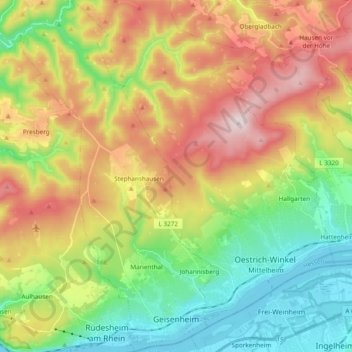
Name: Geisenheim topographic map, elevation, terrain.
Location: Geisenheim, Rheingau-Taunus-Kreis, Hesse, 65366, Germany (49.97498 7.88261 50.09746 7.99220)
Average elevation: 305 m
Minimum elevation: 78 m
Maximum elevation: 626 m
Thank you for supporting this site ❤️
Make a donation
Make a donation