
Charençon topographic map
Interactive map
Click on the map to display elevation.
About this map
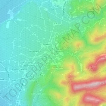
Name: Charençon topographic map, elevation, terrain.
Average elevation: 245 m
Minimum elevation: 105 m
Maximum elevation: 575 m
Other topographic maps
Click on a map to view its topography, its elevation and its terrain.
Montmirail
France > Provence-Alpes-Côte d'Azur > Vaucluse > Gigondas
Montmirail, Gigondas, Carpentras, Vaucluse, Provence-Alpes-Côte d'Azur, France métropolitaine, 84190, France
Average elevation: 201 m
La Gardette
France > Provence-Alpes-Côte d'Azur > Vaucluse > Gigondas
La Gardette, Gigondas, Carpentras, Vaucluse, Provence-Alpes-Côte d'Azur, France métropolitaine, 84190, France
Average elevation: 245 m
Grand Montmirail
France > Provence-Alpes-Côte d'Azur > Vaucluse > Gigondas
Grand Montmirail, Gigondas, Carpentras, Vaucluse, Provence-Alpes-Côte d'Azur, France métropolitaine, 84190, France
Average elevation: 280 m
La Payouse
France > Provence-Alpes-Côte d'Azur > Vaucluse > Gigondas
La Payouse, Gigondas, Carpentras, Vaucluse, Provence-Alpes-Côte d'Azur, France métropolitaine, 84190, France
Average elevation: 258 m
Derrière Vielle
France > Provence-Alpes-Côte d'Azur > Vaucluse > Gigondas
Derrière Vielle, Gigondas, Carpentras, Vaucluse, Provence-Alpes-Côte d'Azur, France métropolitaine, 84190, France
Average elevation: 261 m
La Bergine
France > Provence-Alpes-Côte d'Azur > Vaucluse > Gigondas
La Bergine, Gigondas, Carpentras, Vaucluse, Provence-Alpes-Côte d'Azur, France métropolitaine, 84190, France
Average elevation: 206 m