
Thành phố Nha Trang topographic map
Interactive map
Click on the map to display elevation.
About this map
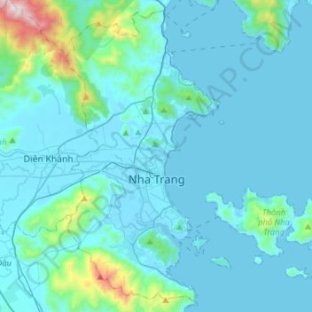
Name: Thành phố Nha Trang topographic map, elevation, terrain.
Location: Thành phố Nha Trang, Province de Khánh Hòa, Viêt Nam (12.14288 109.11288 12.37991 109.37145)
Average elevation: 118 m
Minimum elevation: -2 m
Maximum elevation: 1,315 m
Other topographic maps
Click on a map to view its topography, its elevation and its terrain.
Ba Ho Waterfall
Viêt Nam > Province de Khánh Hòa > Ninh Hòa
Ba Ho Waterfall, Ninh Hòa, Province de Khánh Hòa, Viêt Nam
Average elevation: 183 m