
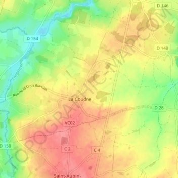
La Coudre topographic map
Interactive map
Click on the map to display elevation.
About this map
Name: La Coudre topographic map, elevation, terrain.
Average elevation: 125 m
Minimum elevation: 86 m
Maximum elevation: 157 m
Other topographic maps
Click on a map to view its topography, its elevation and its terrain.
Boësse
France > Nouvelle-Aquitaine > Deux-Sèvres > Argentonnay
Boësse, Argentonnay, Bressuire, Deux-Sèvres, Nouvelle-Aquitaine, France métropolitaine, 79150, France
Average elevation: 118 m
Sanzay
France > Nouvelle-Aquitaine > Deux-Sèvres > Argentonnay > Sanzay
Sanzay, Argenton-les-Vallées, Argentonnay, Bressuire, Deux-Sèvres, Nouvelle-Aquitaine, France métropolitaine, 79150, France
Average elevation: 121 m
Le Breuil-sous-Argenton
France > Nouvelle-Aquitaine > Deux-Sèvres > Argentonnay
Le Breuil-sous-Argenton, Argentonnay, Bressuire, Deux-Sèvres, Nouvelle-Aquitaine, France métropolitaine, 79150, France
Average elevation: 120 m