
Thank you for supporting this site ❤️
Make a donation
Make a donation
Wingene topographic map
Click on the map to display elevation.
Thank you for supporting this site ❤️
Make a donation
Make a donation
Wingene
Wingene ligt in het overgangsgebied van Zandig Vlaanderen in het noorden en Zandlemig Vlaanderen (Plateau van Tielt) in het zuiden. De hoogte bedraagt 15-39 meter. De belangrijkste waterloop is de Ringbeek die oostelijk van de dorpskom in noordelijke richting stroomt. Het landschap is licht heuvelachtig. Natuurgebieden zijn: Munkebossen, De Gulke Putten, Bulskampveld, Blauwhuisbossen en Vagevuurbossen.
Thank you for supporting this site ❤️
Make a donation
Make a donation
About this map
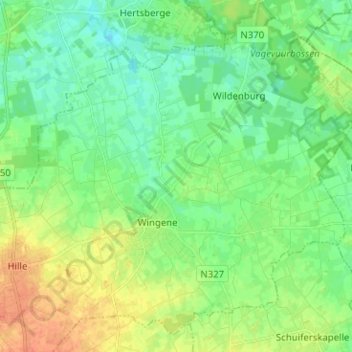
Name: Wingene topographic map, elevation, terrain.
Location: Wingene, Tielt, West-Vlaanderen, Vlaanderen, België (51.03279 3.22414 51.10427 3.34956)
Average elevation: 22 m
Minimum elevation: 8 m
Maximum elevation: 43 m
Thank you for supporting this site ❤️
Make a donation
Make a donation
Other topographic maps
Click on a map to view its topography, its elevation and its terrain.