
Make a donation
Trento topographic map
Click on the map to display elevation.
Make a donation
Trento
The municipality of Trento stretches across a wide range of altitude levels, going from just under 200 m above sea level at the city centre, to 400 m in Povo and Cognola, to 2000 m above sea level at Monte Bondone, boroughs at higher elevation, for instance Viote, have a colder alpine climate (Dw). Urban Trento has a humid subtropical-continental climate (Cfa-Dfa) according to the Köppen climate classification. Monthly average temperatures range between 1.6 °C (January) and 23.4 °C (July). Annual precipitation exceed 900 mm spread out on an average of 87 days, with peaks in late spring (May–June, 90 mm monthly average in 9–10 rain days) and autumn (October–November: 100–110 mm monthly average in 7–8 days), and lows in winter (January–February, 30–40 mm monthly average in 3–4 rain days). Winters are cold to freezing, with infrequent snowfall but usual frost from mid-November to mid-March. In winter daytime highs may not exceed 5°C and lows may rarely dip down to -10°C, but the latter usually stand around -4°C to 0°C. Spring brings unpredictable weather with wind blowing north to south or vice-versa throughout the valley. Many spring days are pleasant, but the transition may be very quick, for example going from frosty mornings to 30°C in two months. In May it's possible to have either rainy days with daytime highs below 18°C, or sunny days with the temperature soaring up to 30°C. Summers are hot, sometimes sweltering, with highs getting to 35°C at least for a week a year and more rarely to 38°C. Summer nights can be hot as well, with overnight lows hovering around 22-24°C (in the hilly suburbs east, north and west of Trento summer nights can be much cooler, with lows up to 6°C lower than that of the city centre). Early fall is pleasant, with foliage starting around mid-October at higher elevations, late October in the uphill suburbs and in November downtown. Fall days can be humid, grey and dim, with temperatures rapidly declining through October and November. The first snowfall in the suburbs may occur as early as late November, with December and early January being the snowiest period of the year.
Make a donation
About this map
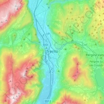
Name: Trento topographic map, elevation, terrain.
Average elevation: 789 m
Minimum elevation: 173 m
Maximum elevation: 2,143 m
Make a donation
Other topographic maps
Click on a map to view its topography, its elevation and its terrain.
Make a donation
Val di Fiemme
Italy > Trentino – Alto Adige/Südtirol > Provincia di Trento > Panchià
Average elevation: 1,640 m
Madonna di Campiglio
Italy > Trentino – Alto Adige/Südtirol > Provincia di Trento
Madonna di Campiglio (German: Sankt Maria im Pein) is a village and a ski resort in northeast Italy. It is a frazione of the comune of Pinzolo. The village lies in the Val Rendena at an elevation of 1,522 m (4,993 ft) above sea level, and has approximately 1,000 inhabitants.
Average elevation: 1,744 m
Make a donation
Cortina
Italy > Trentino – Alto Adige/Südtirol > Provincia di Trento > Vermiglio
Average elevation: 1,534 m
Covelo
Italy > Trentino – Alto Adige/Südtirol > Provincia di Trento > Vallelaghi
Average elevation: 834 m
Lago di Molveno
Italy > Trentino – Alto Adige/Südtirol > Provincia di Trento > Molveno
Average elevation: 1,071 m
Make a donation
Make a donation
Bocca di Valle
Italy > Trentino – Alto Adige/Südtirol > Provincia di Trento > Bondone
Average elevation: 1,258 m
Alpe Cermis
Italy > Trentino – Alto Adige/Südtirol > Provincia di Trento > Cavalese
Average elevation: 1,715 m
Ronchi
Italy > Trentino – Alto Adige/Südtirol > Provincia di Trento > Trento > Mattarello
Average elevation: 339 m
Belvedere
Italy > Trentino – Alto Adige/Südtirol > Provincia di Trento > Pergine Valsugana
Average elevation: 791 m
Make a donation
Make a donation
Valsorda
Italy > Trentino – Alto Adige/Südtirol > Provincia di Trento > Predazzo
Average elevation: 1,785 m
Biacesa di Ledro
Italy > Trentino – Alto Adige/Südtirol > Provincia di Trento
Average elevation: 831 m
Make a donation
Cortina
Italy > Trentino – Alto Adige/Südtirol > Provincia di Trento > Vermiglio
Average elevation: 1,534 m
Saone
Italy > Trentino – Alto Adige/Südtirol > Provincia di Trento > Tione di Trento
Average elevation: 848 m
Karerpass - Jouf de Ciareja - passo Carezza
Italy > Trentino – Alto Adige/Südtirol > Provincia di Trento
Average elevation: 1,869 m
Make a donation
Dossone
Italy > Trentino – Alto Adige/Südtirol > Provincia di Trento > Caderzone Terme
Average elevation: 1,639 m
Camin
Italy > Trentino – Alto Adige/Südtirol > Provincia di Trento > Ziano di Fiemme
Average elevation: 2,022 m
Lago di Lagolo
Italy > Trentino – Alto Adige/Südtirol > Provincia di Trento > Lagolo
Average elevation: 1,004 m
Make a donation
Carbonare
Italy > Trentino – Alto Adige/Südtirol > Provincia di Trento > San Sebastiano
Average elevation: 1,167 m
Bergner Kreuz - Croce di Forcella Piccola
Italy > Trentino – Alto Adige/Südtirol > Provincia di Trento
Average elevation: 1,433 m
Make a donation
Stavel
Italy > Trentino – Alto Adige/Südtirol > Provincia di Trento > Vermiglio
Average elevation: 1,692 m
Cortina
Italy > Trentino – Alto Adige/Südtirol > Provincia di Trento > Vermiglio
Average elevation: 1,534 m
Make a donation
valle dell'Anza
Italy > Trentino – Alto Adige/Südtirol > Provincia di Trento > Levico Terme > Selva di Levico > Masi Rossi
Average elevation: 807 m
Mazza di Pichea
Italy > Trentino – Alto Adige/Südtirol > Provincia di Trento
Average elevation: 1,467 m
Madonna di Campiglio
Italy > Trentino – Alto Adige/Südtirol > Provincia di Trento
Madonna di Campiglio (German: Sankt Maria im Pein) is a village and a ski resort in northeast Italy. It is a frazione of the comune of Pinzolo. The village lies in the Val Rendena at an elevation of 1,522 m (4,993 ft) above sea level, and has approximately 1,000 inhabitants.
Average elevation: 1,744 m
Make a donation
Pian
Italy > Trentino – Alto Adige/Südtirol > Provincia di Trento > Campitello di Fassa > Campitello di Fassa - Ciampedel
Average elevation: 1,797 m
Pozza di Fassa - Poza
Italy > Trentino – Alto Adige/Südtirol > Provincia di Trento
Average elevation: 1,583 m
Passo Tonale
Italy > Trentino – Alto Adige/Südtirol > Provincia di Trento > Vermiglio
Average elevation: 2,064 m
Make a donation
Vigo di Fassa - Vich
Italy > Trentino – Alto Adige/Südtirol > Provincia di Trento
Average elevation: 1,600 m
Nanno
Italy > Trentino – Alto Adige/Südtirol > Provincia di Trento > Ville d'Anaunia
Average elevation: 534 m
Alboletta
Italy > Trentino – Alto Adige/Südtirol > Provincia di Trento > Riva del Garda > Sant'Alessandro
Average elevation: 239 m
Make a donation
Costasavina
Italy > Trentino – Alto Adige/Südtirol > Provincia di Trento > Pergine Valsugana > Susà
Average elevation: 626 m